Nangloi Railway Metro Station (DMRC) connects Green Line with direct rail access, smooth routes, updated timings, and nearby local spots.
Nangloi railway metro station is a vital transit hub on the Green Line of the Delhi Metro network, seamlessly connecting the neighborhoods of West Delhi with other key parts of the city. With its strategic location near the Nangloi Railway Station, this metro stop efficiently serves both daily commuters and long-distance travelers, acting as a bridge between metro services and Northern Railway’s local and express routes. It is known for modern design, accessibility, and user-friendly facilities, making the station a cornerstone of mobility in the rapidly developing areas of Nangloi, Mundka, and adjoining localities. This blog explores everything you need to know about Nangloi railway metro station in a detailed, SEO-optimized format.
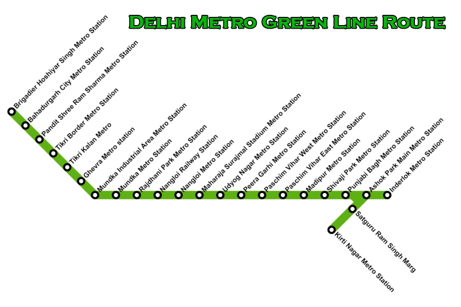
Delhi Metro Green Line Route
| Station Name | Line/Interchange | Distance (km) | Fare (₹) | Travel Time (min) |
| Kirti Nagar | Green Line / Blue Line | 0.0 | 10 | 0 |
| Satguru Ram Singh Marg | Green Line | 1.2 | 10 | 2 |
| Inderlok | Green Line / Red Line | 2.5 | 20 | 3 |
| Ashok Park Main | Green Line / Green Line Branch | 5.0 | 20 | 6 |
| Punjabi Bagh | Green Line | 6.5 | 30 | 8 |
| Punjabi Bagh West | Green Line | 7.5 | 30 | 10 |
| Shivaji Park | Green Line | 8.5 | 30 | 11 |
| Madipur | Green Line | 9.5 | 30 | 12 |
| Paschim Vihar East | Green Line | 10.5 | 30 | 14 |
| Paschim Vihar West | Green Line / Blue Line | 11.5 | 30 | 15 |
| Peera Garhi | Green Line | 12.5 | 40 | 16 |
| Udyog Nagar | Green Line | 13.5 | 40 | 17 |
| Surajmal Stadium | Green Line | 14.5 | 40 | 19 |
| Nangloi | Green Line | 15.5 | 40 | 20 |
| Nangloi Railway Station | Green Line | 16.5 | 40 | 21 |
| Rajdhani Park | Green Line | 17.5 | 40 | 23 |
| Mundka | Green Line | 19.0 | 40 | 24 |
| Mundka Industrial Area | Green Line | 20.0 | 40 | 26 |
| Ghevra | Green Line | 21.0 | 40 | 27 |
| Tikri Kalan | Green Line | 22.0 | 50 | 28 |
| Tikri Border | Green Line | 23.0 | 50 | 30 |
| Pandit Shree Ram Sharma | Green Line | 24.0 | 50 | 31 |
| Bahadurgarh City | Green Line | 25.5 | 50 | 33 |
| Brigadier Hoshiyar Singh | Green Line | 27.96 | 50 | 36 |
Historical Background
The area of Nangloi has a rich history that predates modern urban development, being once a peripheral village on the outskirts of Delhi. The Nangloi railway metro station, opened as part of Delhi Metro’s Phase II expansion, brought rapid urban connectivity to a region traditionally tied to railway mobility via the Nangloi Railway Station (Northern Railway). With its inauguration in 2010, Nangloi Railway Metro Station became a transformative hub, catalyzing local commerce, reducing travel times, and encouraging residential growth. Since then, modernization and population influx have established Nangloi railway metro station as one of the busiest stations on the Green Line, reflecting the area’s urbanization and growing importance in West Delhi.
General Information
| Feature | Details |
|---|---|
| Metro Line | Green Line (Line 5) |
| Station Type | Elevated |
| Platforms | 2 (Side platforms) |
| Inauguration Date | 2 April 2010 |
| Operating Hours | Approx. 6:00 AM to 11:00 PM |
| Address | Rohtak Road, Opposite Surajmal Stadium, Nangloi, Delhi |
| Parking | Available (Paid for two-wheelers and cars) |
| Fare Range | ₹10 – ₹60 (depending on travel distance) |
| Owner | Delhi Metro Rail Corporation Ltd. (DMRC) |
This station provides an efficient and well-managed environment for commuters, with essential services such as ticket vending machines, fare control counters, and seating arrangements available at the concourse level.
Construction
Construction of Nangloi metro station began around 2008 during Phase 1 and Phase 2 expansions of the Delhi Metro, incorporating modern elevated station design. The elevated structure ensures seamless integration into the busy Rohtak Road corridor while minimizing ground-level traffic disruption. Key construction elements included reinforced concrete platforms, roofing with structural steel, and incorporation of utilities essential for passenger safety and convenience. The station’s elevated design also improves accessibility for nearby neighborhoods, allowing commuters to easily walk, cycle, or take feeder transport to access the station.
Station Layout
The station layout is designed for efficient passenger movement and operational convenience. The station comprises two main levels above ground:
| Level | Description |
|---|---|
| G (Ground) | Entry/Exit gates, street-level access to platforms |
| L1 | Concourse level with fare control, ticketing counters, and metro card vending machines |
| L2 | Two side platforms serving two tracks for eastbound and westbound trains |
Platform 1 is designated for westbound trains heading toward Brigadier Hoshiyar Singh (Bahadurgarh), while Platform 2 accommodates eastbound trains traveling toward Inderlok and Kirti Nagar in Central Delhi. Doors open on the left side of trains at both platforms for smooth boarding and alighting. Interconnections between platforms are facilitated via staircases, escalators, and elevators.
Entry/Exit Gates and Facilities
Nangloi metro station has two primary entry and exit gates for easy commuter access:
| Gate Number | Leading To | Accessibility |
|---|---|---|
| 1 | Kirari More, Delhi Police Staff Quarters | Yes |
| 2 | Government Sarvodaya Bal Kanya Vidyalaya, Government Girls Senior Secondary School | Yes |
Facilities available at the station include:
Ticket vending machines and ticket counters
Paid parking facilities for two-wheelers and cars
ATM services (HDFC Bank, State Bank of India, Yes Bank)
Sulabh toilets for public convenience
Drinking water facilities
Disabled-friendly ramps and elevators
These amenities ensure a comfortable and accessible commute for passengers, including differently-abled individuals.
Location and Connectivity
Nangloi railway metro station is situated along Rohtak Road in the Nangloi area of West Delhi. The station’s address is Nangloi, Najafgarh Road, Delhi, 110041. It stands adjacent to the Nangloi Railway Station, enabling simple transfers between train and metro. This location gives it a unique advantage, as it not only offers direct metro access but also facilitates travel across North India via Indian Railways.
| Connectivity Mode | Details |
| Metro | Green Line (Inderlok/Kirti Nagar – Brig Hoshiar Singh) |
| Rail | Nangloi Railway Station (Delhi division, NR) |
| Bus | DTC and cluster buses along Rohtak Road, Jwala Puri |
| Road | Access via Rohtak Road, Najafgarh Road, Mundka Road |
| Airport | Indirect, via metro interchanges and Airport Line |
The station connects easily with several Delhi metro corridors through interchange at Inderlok and Kirti Nagar. It caters to large residential, educational, and commercial catchments in western Delhi and Haryana.
Metro Gates and Facilities
Nangloi railway metro station is equipped with multiple entry and exit gates, each serving different directions and localities. Its elevated platforms, wide concourse area, and clear signage make passenger movement smooth even during peak hours.
| Gate No. | Main Access Point | Facilities Present |
| 1 | Nangloi Railway Station approach | Ramp, elevator, ticket counter, ATM |
| 2 | Najafgarh Road, Jwala Puri side | Escalator, public toilets, water point |
| 3 | Nangloi main market side, local buses | Elevator, customer care, E-rickshaw stand |
| 4 | Rohtak Road side | Ramp, auto stand, cycle parking |
Facilities include:
- Wide staircases and escalators for both platforms.
- Ticket counters and recharge kiosks.
- Public toilets and drinking water on concourse and platform levels.
- Waiting and resting area in concourse.
- Electronic display boards and clear voice announcements for arrivals.
Public Transport Availability
Nangloi railway metro station is a transit hub that integrates with many public transportation options, offering robust last-mile connectivity.
| Mode of Transport | Frequency | Notes |
| DTC City Buses | Very frequent | Connects to central, west, north Delhi |
| Cluster Buses | Frequent | Direct links to Rajouri Garden, Uttam Nagar |
| Auto Rickshaws | Readily available | Last-mile trips, connects to local sector |
| E-rickshaws | High availability | Eco-friendly for micro routes |
| Taxis/Rideshares | On-call/app-based | Cabs, ride-share options via apps |
| Cycle Parking | Available | Parking and stand for cycles |
The bus stops adjacent to the metro station serve as feeder points to nearby colonies, colleges, and industrial areas, making daily commutes convenient.
Accessibility Features
Designed for inclusivity, Nangloi railway metro station provides features to support passengers with special needs, families, and seniors.
| Feature | Description |
| Ramps and Elevators | At every gate and used for all platforms |
| Tactile Flooring | Guidance for visually impaired passengers |
| Disabled-Friendly Toilets | At concourse level near ticket counter |
| Reserved Seating | Priority marked on platform and in trains |
| Wide Entry Gates | Suitable for wheelchairs, strollers |
| Audio Announcements | Hindi/English for movement and emergencies |
| Clear Visual Signage | Large, bilingual, and easy to identify |
| Wheelchair Loan Availability | On request at customer service |
These features ensure that Nangloi railway metro station is truly accessible, comfortable, and convenient for all.
Navigating Metro Station
The station’s layout spans three levels: ground (entry/exit), concourse (ticketing, access), and elevated platforms (boarding).
| Level | Facilities Available |
| Ground | Bus, autos, cycle stand, entry gates, local shops |
| Concourse | Ticket counters, toilets, recharge kiosk, waiting |
| Platform | Digital info, benches, security, boarding areas |
A single centralized concourse under the elevated tracks facilitates transfer between metro and train without losing orientation. Digital indicators provide real-time arrival and departure updates. Clear maps and directional signage help newcomers seamlessly navigate the entire facility.
Nearby Markets and Attractions
The area around Nangloi railway metro station is lively and diverse, with plenty of shopping and entertainment options.
| Market/Attraction | Distance from Station | Type | Notable Offerings |
| Nangloi Main Market | 0.2 km | Shopping | Apparel, groceries, daily goods |
| Jwala Puri Market | 0.6 km | Shopping | Footwear, electronics, fabrics |
| Rani Bagh Mandi | 1.5 km | Market | Wholesale vegetables and fruits |
| Pacific Mall Subhash Nagar | 7.5 km | Mall | Brands, cinema, food court |
| Dada De Mandir (Temple) | 2.0 km | Religious | Historic, local festivals |
| Nangloi Dairy Aquarium | 1.1 km | Family fun | Kids’ corner, fresh products |
Street vendors, snack stalls, pharmacies, and daily needs outlets line the approach roads, providing everything required for daily living or commuting.
Nearby Residential and Commercial Properties
The station’s catchment spans diverse residential neighborhoods and new real estate hotspots, boosting demand for property and rental housing.
| Locality/Area | Distance | Property Type | Notable Features | Avg. Price (₹/sq.ft) |
| Nangloi Extension | 0.3 km | Low/mid-rise | Schools, parks, clinics | 7,000–11,000 |
| Jwala Puri | 1.1 km | Builder floors | Market, transport links | 8,500–12,000 |
| Mundka | 3.5 km | Apartments | Warehouses, factories, schools | 5,500–9,500 |
| Rajdhani Park | 1.7 km | Residential | Affordable segment, bus routes | 6,500–9,000 |
| Rohtak Road (commercial) | 0.1 km | Office/retail | Automobile showrooms, logistics | Varies |
| Kamaruddin Nagar | 1.5 km | Mixed-use | Small businesses, grocery shops | 6,000–8,000 |
Increased connectivity has raised property values and rental demand, especially for families and working professionals.
User Review and Passenger Experience
Users consistently praise Nangloi railway metro station for:
- Prompt and frequent train services, minimizing wait times.
- Clean premises, efficient security, and responsive staff.
- Ease of switching between metro and mainline trains.
- Ample signage, digital displays, and audio-visual alerts, making it simple for first-time visitors.
- Safe environment even during late hours, supported by diligent security presence.
Complaints tend to be around peak-hour crowding and demand for more direct feeder buses, especially on weekends and in festival seasons.
Most users highlight trouble-free ticketing, regular cleaning of public areas, and easy availability of last-mile transport as strong positives.
Security Features
Safety at Nangloi railway metro station is robust, featuring multiple layers of security.
| Feature | Details |
| CCTV Surveillance | 24×7, all common and critical areas |
| Baggage Scanners & Metal Detectors | At every entry gate |
| Security Personnel | Deployed on platforms, concourses |
| Emergency Response System | Panic buttons, first aid room |
| Fire Safety | PA system, fire extinguishers, alarms |
| Night Patrolling | Enhanced during off-peak, late night |
Emergency phones and regular drills improve preparedness, while bag and person screening at entry keeps the station secure for all passengers.
Nearby Metro Stations
Its central Green Line location means easy access to adjacent and connecting stations.
| Station Name | Direction | Distance (Approx.) | Key Details |
| Nangloi (non-rail) | West | 1.2 km | Serves Nagloi localities |
| Rajdhani Park | West | 2.4 km | Mixed-use commuter locality |
| Mundka | North-west | 4.2 km | Industrial/commercial zone |
| Peeragarhi | East | 2.8 km | Interchange with other bus routes |
| Inderlok | Central | 9.5 km | Interchange with Red Line |
| Kirti Nagar | South-east | 12.8 km | Interchange with Blue Line |
Connectivity to Important Locations
Nangloi railway metro station offers direct and connecting links to Delhi’s most important hubs.
| Destination | Route | Approx. Time | Notes |
| Connaught Place | Green to Red/Blue Line | 45 mins | 1 interchange, city center |
| Indira Gandhi Int’l Airport | Green to Magenta/Airport Line | 70 mins | 2 interchanges |
| Old Delhi Railway Station | Green to Red Line | 50 mins | 1 interchange |
| ISBT Kashmere Gate | Green to Red Line | 60 mins | Major interstate bus station |
| Peeragarhi | Direct, Green Line | 6 mins | Bus/industrial connector |
| Mundka Industrial Area | Direct, Green Line | 10 mins | Manufacturing hub |
| Wazirpur (North Delhi) | Green-Red-Yellow Lines | 65 mins | Multiple interchanges |
Conclusion
Nangloi railway metro station has evolved into a central transportation hub for West Delhi, recognized for its role in improving mobility and spurring regional growth. It bridges traditional railway travel with the speed and convenience of the Delhi Metro, thereby meeting the needs of daily commuters, business travelers, and families alike. With user-friendly facilities, robust security, excellent accessibility features, and strong integration with local markets, property clusters, and business hubs, the station is a model of modern, sustainable public transit. As Delhi continues to expand, Nangloi railway metro station will remain a vital part of the city’s infrastructure, supporting its aspirations for smart, connected, and inclusive urban living.