Delhi Metro Map 2025, Download the newest route map pdfa with updated lines, station details, and distances for a smooth Delhi travel experience.
Download Updated Route PDF – Delhi Metro Map PDF
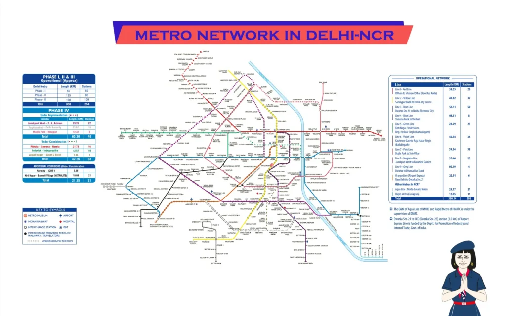
Delhi Metro Map (DMRC) guides commuters with routes, lines, stations, and distances, ensuring smooth travel across Delhi-NCR. Delhi Metro Map is a crucial tool for navigating the vast and ever-expanding metro network of India’s capital. It provides a clear representation of all metro lines, stations, and interchange points, making travel convenient for millions of passengers every day. With over 285 stations spread across multiple lines, the Delhi Metro connects various parts of Delhi, Noida, Ghaziabad, Gurgaon, and Faridabad.
We can also divide Delhi Metro in Central Delhi, North Delhi, South Delhi, East Delhi and West Delhi.
The map is color-coded, with each metro line assigned a specific color to help commuters easily identify their routes. It highlights key interchange stations where passengers can switch between different lines for a seamless journey. The Delhi Metro Map also includes important symbols for accessibility features, express services, and connectivity to major railway stations and the airport.
With digital integration, the Delhi Metro Map is available online and through mobile apps, allowing commuters to plan their trips in advance. It helps in estimating travel time, checking fares, and understanding station facilities. The expansion of the metro network continues to improve connectivity, making the map an essential guide for daily commuters, students, professionals, and tourists alike. Understanding the Delhi Metro Map ensures a hassle-free travel experience while navigating one of India’s most efficient public transport systems.
Evolution of the Delhi Metro Map
The Delhi Metro Map has evolved significantly since the metro’s launch in 2002. Initially, it featured a simple layout with just one operational line, the Red Line, covering a few stations. As the network expanded, new lines were introduced with distinct colors to enhance readability. Interchange stations were added to improve connectivity between different routes. Over time, the map became more detailed, incorporating feeder bus services, accessibility symbols, and express routes. With digital integration, it is now accessible on mobile apps and websites, helping commuters navigate efficiently. The continuous expansion of the metro system ensures further evolution of the map.
Early Days of the Metro Map
In the early days, the Delhi Metro Map was simple, featuring only the Red Line when operations began in 2002. With limited stations and no interchange points, navigation was straightforward. As new lines were added, the map evolved, introducing color codes and detailed layouts to enhance commuter convenience and connectivity.
Expansion and Major Changes
The Delhi Metro has undergone significant expansion, growing from a single line in 2002 to a vast network covering Delhi, Noida, Gurgaon, Ghaziabad, and Faridabad. New lines, interchange stations, and digital accessibility have enhanced connectivity. Ongoing Phase 4 expansions will further improve travel convenience for millions of daily commuters.
Current Delhi Metro Route Map Design
The current Delhi Metro Route Map features a well-structured, color-coded design covering over 285 stations across 10 lines. It highlights interchange stations, airport connectivity, and accessibility features. Available in both print and digital formats, the map ensures seamless navigation for commuters, making travel across Delhi and NCR efficient and hassle-free.
Today, the Delhi Metro Map is highly detailed, showcasing:
- 10 color-coded metro lines
- Multiple interchange stations
- Extension routes into neighboring cities
- Accessibility information
- Express and feeder bus services
Understanding the New Delhi Metro Map
Understanding the New Delhi Metro Map is essential for seamless travel across the city. The map is color-coded, with each metro line assigned a specific color for easy identification. It highlights interchange stations where passengers can switch between lines, ensuring smooth connectivity. Symbols on the map indicate accessibility features, airport express services, and railway station links. Digital versions are available on apps, helping commuters plan routes, check fares, and estimate travel time. With over 285 stations, the map simplifies navigation for daily commuters, tourists, and professionals. A clear understanding of the map ensures an efficient and hassle-free metro journey.
The New Delhi Metro Map follows a color-coded format, making it easy to read and use. Here’s how you can understand it:
Metro Line Colors and Their Routes
The Delhi Metro network consists of color-coded lines for easy navigation. Key routes include the Red Line (Rithala to Shaheed Sthal), Yellow Line (Samaypur Badli to HUDA City Centre), Blue Line (Dwarka Sector 21 to Noida/Vaishali), and others like Green, Violet, Magenta, Pink, Grey, and the Airport Express Line.
Each metro line is represented by a specific color:
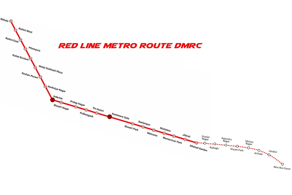
- Red Line: Rithala – Shaheed Sthal (Ghaziabad)
- Yellow Line: Samaypur Badli – HUDA City Centre
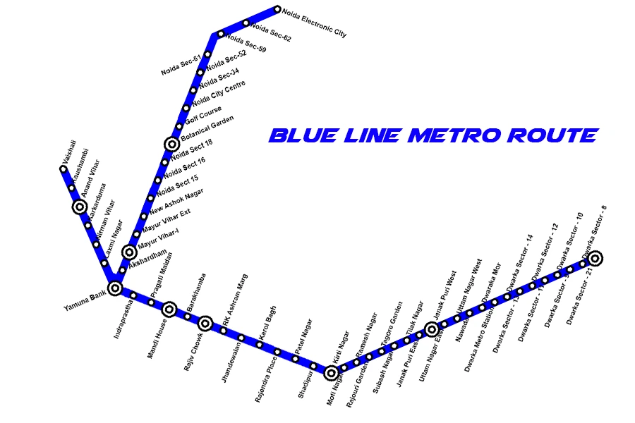
- Blue Line: Dwarka Sector 21 – Noida City Centre / Vaishali
- Green Line: Inderlok / Kirti Nagar – Brigadier Hoshiyar Singh
- Violet Line: Kashmere Gate – Raja Nahar Singh (Ballabhgarh)
- Magenta Line: Janakpuri West – Botanical Garden
- Pink Line: Majlis Park – Shiv Vihar
- Grey Line: Dwarka – Dhansa Bus Stand
- Airport Express Line(Orange Line): New Delhi – Dwarka Sector 21
Delhi Metro Red Line Route
| # | Station | Line/Interchange | Distance (km) | Time (min) | Fare (₹) |
| 1 | Shaheed Sthal | Red Line | 0.0 | 0 | 10 |
| 2 | Hindon River | Red Line | 2.5 | 3 | 10 |
| 3 | Arthala | Red Line | 4.8 | 6 | 10 |
| 4 | Mohan Nagar | Red Line | 7.0 | 9 | 20 |
| 5 | Shyam Park | Red Line | 9.2 | 11 | 20 |
| 6 | Major Mohit Sharma | Red Line | 11.0 | 13 | 20 |
| 7 | Raj Bagh | Red Line | 13.0 | 15 | 20 |
| 8 | Shaheed Nagar | Red Line | 15.0 | 17 | 20 |
| 9 | Dilshad Garden | Red Line | 17.0 | 19 | 20 |
| 10 | Jhilmil | Red Line | 19.0 | 21 | 20 |
| 11 | Mansarovar Park | Red Line | 21.0 | 23 | 20 |
| 12 | Shahdara | Red Line | 23.0 | 25 | 20 |
| 13 | Welcome | Red Line/Pink Line | 25.0 | 28 | 30 |
| 14 | Seelampur | Red Line | 27.0 | 30 | 30 |
| 15 | Shastri Park | Red Line | 29.0 | 32 | 30 |
| 16 | Kashmere Gate | Red Line/Yellow & Violet Lines | 31.0 | 35 | 30 |
| 17 | Tis Hazari | Red Line | 33.0 | 37 | 30 |
| 18 | Pul Bangash | Red Line | 35.0 | 40 | 40 |
| 19 | Pratap Nagar | Red Line | 37.0 | 43 | 40 |
| 20 | Shastri Nagar | Red Line | 39.0 | 45 | 40 |
| 21 | Inderlok | Red Line/Green Line | 41.0 | 48 | 40 |
| 22 | Kanhaiya Nagar | Red Line | 43.0 | 50 | 40 |
| 23 | Keshav Puram | Red Line | 45.0 | 52 | 40 |
| 24 | Netaji Subhash Place | Red Line/Pink Line | 47.0 | 55 | 40 |
| 25 | Kohat Enclave | Red Line | 49.0 | 58 | 40 |
| 26 | Pitampura | Red Line | 51.0 | 60 | 40 |
| 27 | Rohini East | Red Line | 33.48? | 62 | 40 |
| 28 | Rohini West | Red Line | 33.48? | 64 | 40 |
| 29 | Rithala | Red Line | 34.55 | 67 | 40 |
Delhi Metro Yellow Line Route

| Station Name | Metro Line | Travel Time (Minutes) | Distance (km) | Approx. Fare (₹) |
| Samaypur Badli | Yellow | 0(Starting Point) | 0 | 0 |
| Rohini Sector 18, 19 | Yellow | 8 | 4.0 | 20 |
| Haiderpur Badli Mor | Yellow | 10 | 5.0 | 20 |
| Jahangirpuri | Yellow | 7 | 3.5 | 20 |
| Adarsh Nagar | Yellow | 5 | 2.5 | 20 |
| Azadpur | Yellow | 3 | 1.5 | 10 |
| Model Town | Yellow | 2 | 1.2 | 10 |
| GTB Nagar | Yellow | 2 | 1.2 | 10 |
| Vishwavidyalaya | Yellow | 2 | 1.2 | 10 |
| Vidhan Sabha | Yellow | 3 | 1.8 | 10 |
| Civil Lines | Yellow | 5 | 2.8 | 20 |
| Kashmere Gate | Yellow | 7 | 3.6 | 20 |
| Chandni Chowk | Yellow | 10 | 5.5 | 20 |
| Chawri Bazar | Yellow | 12 | 6.5 | 20 |
| New Delhi | Yellow | 15 | 8.4 | 30 |
| Rajiv Chowk | Yellow | 18 | 10.2 | 30 |
| Patel Chowk | Yellow | 20 | 11.8 | 30 |
| Central Secretariat | Yellow | 22 | 13.2 | 30 |
| Udyog Bhawan | Yellow | 24 | 14.7 | 40 |
| Lok Kalyan Marg | Yellow | 26 | 15.8 | 40 |
| Jor Bagh | Yellow | 28 | 16.9 | 40 |
| INA | Yellow | 30 | 18.2 | 40 |
| AIIMS | Yellow | 32 | 19.4 | 40 |
| Green Park | Yellow | 34 | 20.8 | 40 |
| Hauz Khas | Yellow | 36 | 22.3 | 50 |
| Malviya Nagar | Yellow | 38 | 23.5 | 50 |
| Saket | Yellow | 40 | 24.9 | 50 |
| Qutub Minar | Yellow | 43 | 26.5 | 50 |
| Chhattarpur | Yellow | 45 | 28.2 | 50 |
| Sultanpur | Yellow | 47 | 29.8 | 50 |
| Ghitorni | Yellow | 50 | 31.4 | 50 |
| Arjan Garh | Yellow | 52 | 33.0 | 50 |
| Guru Dronacharya | Yellow | 54 | 34.8 | 50 |
| Sikanderpur | Yellow | 56 | 36.3 | 50 |
| MG Road | Yellow | 58 | 37.8 | 50 |
| IFFCO Chowk | Yellow | 60 | 39.2 | 50 |
| HUDA City Centre | Yellow | 62 | 41.2 | 50 |
Delhi Metro Blue Line Route
| No. | Station Name | Line/Interchange | Distance (km)* | Fare (₹)* | Time (mins)* |
| 1 | Dwarka Sector 21 metro station | Blue Line | 30.6 | ₹50 | ~52 |
| 2 | Dwarka Sector 8 metro station | Blue Line | 29.2 | ₹50 | ~50 |
| 3 | Dwarka Sector 9 metro station | Blue Line | 27.9 | ₹50 | ~48 |
| 4 | Dwarka Sector 10 metro station | Blue Line | 26.6 | ₹50 | ~46 |
| 5 | Dwarka Sector 11 metro station | Blue Line | 25.2 | ₹50 | ~44 |
| 6 | Dwarka Sector 12 metro station | Blue Line | 23.9 | ₹50 | ~42 |
| 7 | Dwarka Sector 13 metro station | Blue Line | 22.7 | ₹50 | ~40 |
| 8 | Dwarka Sector 14 metro station | Blue Line | 21.3 | ₹50 | ~38 |
| 9 | Dwarka metro station | Blue Line | 20.0 | ₹50 | ~36 |
| 10 | Dwarka Mor metro station | Blue Line | 18.7 | ₹50 | ~34 |
| 11 | Nawada metro station | Blue Line | 17.5 | ₹50 | ~32 |
| 12 | Uttam Nagar West metro station | Blue Line | 16.2 | ₹50 | ~30 |
| 13 | Uttam Nagar East metro station | Blue Line | 14.9 | ₹50 | ~28 |
| 14 | Janakpuri West metro station | Blue/Magenta (Interchange) | 13.6 | ₹40 | ~26 |
| 15 | Janakpuri East metro station | Blue Line | 12.3 | ₹40 | ~24 |
| 16 | Tilak Nagar metro station | Blue Line | 11.1 | ₹40 | ~22 |
| 17 | Subhash Nagar metro station | Blue Line | 9.8 | ₹40 | ~20 |
| 18 | Tagore Garden metro station | Blue Line | 8.5 | ₹30 | ~18 |
| 19 | Rajouri Garden metro station | Blue/Pink (Interchange) | 7.2 | ₹30 | ~16 |
| 20 | Ramesh Nagar metro station | Blue Line | 6.0 | ₹30 | ~14 |
| 21 | Moti Nagar metro station | Blue Line | 4.8 | ₹30 | ~12 |
| 22 | Kirti Nagar metro station | Blue/Green (Interchange) | 3.5 | ₹20 | ~10 |
| 23 | Shadipur metro station | Blue Line | 2.2 | ₹20 | ~8 |
| 24 | Karol Bagh metro station | Blue Line | 0.0 | ₹0 | 0 |
| 25 | Rajendra Place metro station | Blue Line | 1.2 | ₹10 | ~2 |
| 26 | Patel Nagar metro station | Blue Line | 2.5 | ₹20 | ~4 |
| 27 | Rajiv Chowk metro station | Blue/Yellow (Interchange) | 4.8 | ₹30 | ~10 |
| 28 | Barakhamba Road metro station | Blue Line | 6.0 | ₹30 | ~12 |
| 29 | Mandi House metro station | Blue/Violet (Interchange) | 7.3 | ₹30 | ~14 |
| 30 | Pragati Maidan metro station | Blue Line | 8.6 | ₹30 | ~16 |
| 31 | Indraprastha metro station | Blue Line | 9.9 | ₹30 | ~18 |
| 32 | Yamuna Bank metro station | Blue Line (Interchange) | 11.2 | ₹40 | ~20 |
| 33 | Laxmi Nagar metro station | Blue Line | 12.5 | ₹40 | ~22 |
| 34 | Nirman Vihar metro station | Blue Line | 13.8 | ₹40 | ~24 |
| 35 | Preet Vihar metro station | Blue Line | 15.0 | ₹40 | ~26 |
| 36 | Karkarduma metro station | Blue/Orange (Interchange) | 16.3 | ₹40 | ~28 |
| 37 | Anand Vihar ISBT metro station | Blue/Orange (Interchange) | 17.6 | ₹50 | ~30 |
| 38 | Kaushambi metro station | Blue Line | 18.9 | ₹50 | ~32 |
| 39 | Vaishali metro station | Blue Line (Terminal) | 20.2 | ₹50 | ~34 |
| 40 | Akshardham metro station | Blue Line | 13.6 | ₹40 | ~24 |
| 41 | Mayur Vihar Phase 1 metro station | Blue Line | 14.9 | ₹40 | ~26 |
| 42 | Mayur Vihar Extension metro station | Blue Line | 16.2 | ₹40 | ~28 |
| 43 | New Ashok Nagar metro station | Blue Line | 17.5 | ₹50 | ~30 |
| 44 | Noida Sector 15 metro station | Blue Line | 18.8 | ₹50 | ~32 |
| 45 | Noida Sector 16 metro station | Blue Line | 20.1 | ₹50 | ~34 |
| 46 | Noida Sector 18 metro station | Blue Line | 21.4 | ₹50 | ~36 |
| 47 | Botanical Garden metro station | Blue/Magenta (Interchange) | 22.7 | ₹50 | ~38 |
| 48 | Golf Course metro station | Blue Line | 24.0 | ₹50 | ~40 |
| 49 | Noida City Centre metro station | Blue Line (Terminal) | 25.3 | ₹50 | ~42 |
| 50 | Noida Sector 34 Metro Station | Blue Line | 26.0 | ₹60 | ~45 |
| 51 | Noida Sector 52 Metro Station | Blue Line | 27.2 | ₹60 | ~47 |
| 52 | Noida Sector 61 Metro Station | Blue Line | 28.5 | ₹60 | ~49 |
| 53 | Noida Sector 59 Metro Station | Blue Line | 30.0 | ₹60 | ~51 |
| 54 | Noida Sector 62 Metro Station | Blue Line | 30.9 | ₹60 | ~53 |
| 55 | Noida Electronic City Metro Station | Blue Line | 31.6 | ₹60 | ~55 |
Delhi Metro Green Line Route
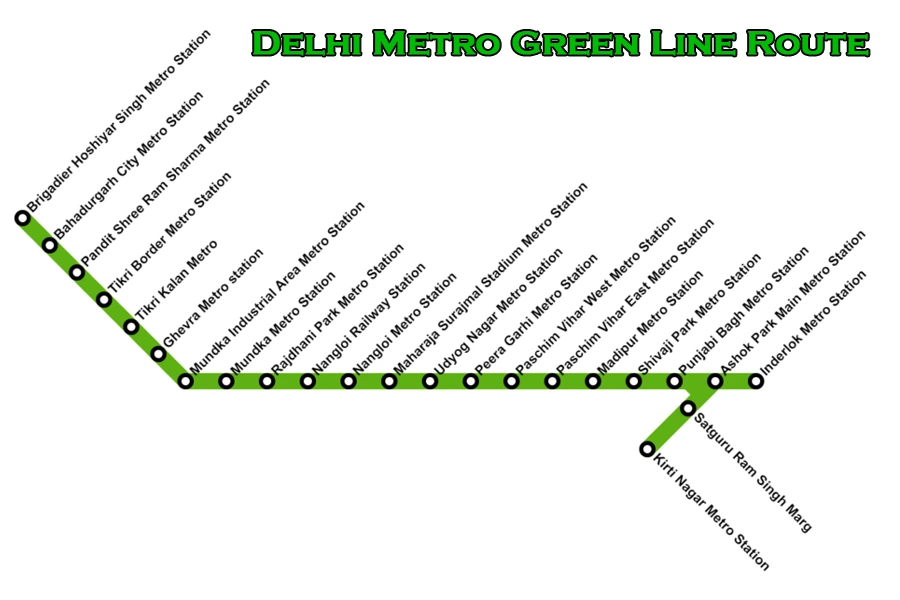
| Station Name | Line/Interchange | Distance (km) | Fare (₹) | Travel Time (min) |
| Kirti Nagar | Green Line / Blue Line | 0.0 | 10 | 0 |
| Satguru Ram Singh Marg | Green Line | 1.2 | 10 | 2 |
| Inderlok | Green Line / Red Line | 2.5 | 20 | 3 |
| Ashok Park Main | Green Line / Green Line Branch | 5.0 | 20 | 6 |
| Punjabi Bagh | Green Line | 6.5 | 30 | 8 |
| Punjabi Bagh West | Green Line | 7.5 | 30 | 10 |
| Shivaji Park | Green Line | 8.5 | 30 | 11 |
| Madipur | Green Line | 9.5 | 30 | 12 |
| Paschim Vihar East | Green Line | 10.5 | 30 | 14 |
| Paschim Vihar West | Green Line / Blue Line | 11.5 | 30 | 15 |
| Peera Garhi | Green Line | 12.5 | 40 | 16 |
| Udyog Nagar | Green Line | 13.5 | 40 | 17 |
| Surajmal Stadium | Green Line | 14.5 | 40 | 19 |
| Nangloi | Green Line | 15.5 | 40 | 20 |
| Nangloi Railway Station | Green Line | 16.5 | 40 | 21 |
| Rajdhani Park | Green Line | 17.5 | 40 | 23 |
| Mundka | Green Line | 19.0 | 40 | 24 |
| Mundka Industrial Area | Green Line | 20.0 | 40 | 26 |
| Ghevra | Green Line | 21.0 | 40 | 27 |
| Tikri Kalan | Green Line | 22.0 | 50 | 28 |
| Tikri Border | Green Line | 23.0 | 50 | 30 |
| Pandit Shree Ram Sharma | Green Line | 24.0 | 50 | 31 |
| Bahadurgarh City | Green Line | 25.5 | 50 | 33 |
| Brigadier Hoshiyar Singh | Green Line | 27.96 | 50 | 36 |
Delhi Metro Violet Line Route
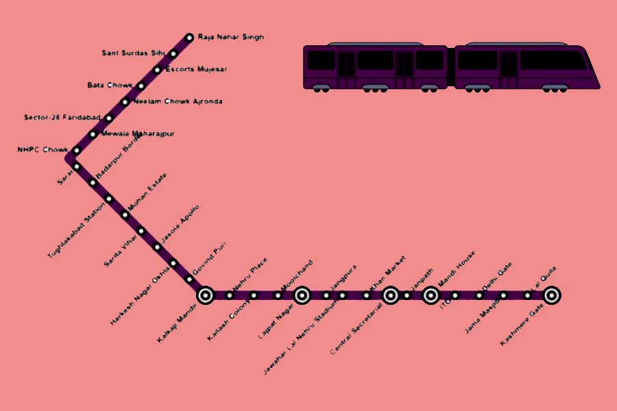
| S. No. | Station Name | Line | Approx. Distance (km) | Travel Time (min) | Fare (₹) from Kashmere Gate |
| 1 | Kashmere Gate | Violet | 0.0 | 0 | – |
| 2 | Lal Qila | Violet | 1.4 | 2 | 10 |
| 3 | Jama Masjid | Violet | 2.8 | 4 | 10 |
| 4 | Delhi Gate | Violet | 4.2 | 6 | 20 |
| 5 | ITO | Violet | 5.6 | 8 | 20 |
| 6 | Mandi House | Violet | 7.0 | 10 | 20 |
| 7 | Janpath | Violet | 8.4 | 12 | 20 |
| 8 | Central Secretariat | Violet | 9.8 | 14 | 20 |
| 9 | Khan Market | Violet | 11.2 | 16 | 30 |
| 10 | Jawaharlal Nehru Stadium | Violet | 12.6 | 18 | 30 |
| 11 | Jangpura | Violet | 14.0 | 20 | 30 |
| 12 | Lajpat Nagar | Violet | 15.4 | 22 | 40 |
| 13 | Moolchand | Violet | 16.8 | 24 | 40 |
| 14 | Kailash Colony | Violet | 18.2 | 26 | 40 |
| 15 | Nehru Place | Violet | 19.6 | 28 | 40 |
| 16 | Kalkaji Mandir | Violet | 21.0 | 30 | 40 |
| 17 | Govindpuri | Violet | 22.4 | 32 | 50 |
| 18 | Harkesh Nagar Okhla | Violet | 23.8 | 34 | 50 |
| 19 | Jasola Apollo | Violet | 25.2 | 36 | 50 |
| 20 | Sarita Vihar | Violet | 26.6 | 38 | 50 |
| 21 | Mohan Estate | Violet | 28.0 | 40 | 50 |
| 22 | Tughlakabad | Violet | 29.4 | 42 | 60 |
| 23 | Badarpur Border | Violet | 30.8 | 44 | 60 |
| 24 | Sarai | Violet | 32.2 | 46 | 60 |
| 25 | NHPC Chowk | Violet | 33.6 | 48 | 60 |
| 26 | Mewla Maharajpur | Violet | 35.0 | 50 | 60 |
| 27 | Sector 28 | Violet | 36.4 | 52 | 60 |
| 28 | Badkhal Mor | Violet | 37.8 | 54 | 60 |
| 29 | Old Faridabad | Violet | 39.2 | 56 | 60 |
| 30 | Neelam Chowk Ajronda | Violet | 40.6 | 58 | 60 |
| 31 | Bata Chowk | Violet | 42.0 | 60 | 60 |
| 32 | Escorts Mujesar | Violet | 43.4 | 62 | 60 |
| 33 | Sant Surdas (Sihi) | Violet | 44.8 | 63 | 60 |
| 34 | Raja Nahar Singh | Violet | 46.2 | 64 | 60 |
Delhi Metro Magenta Line Route
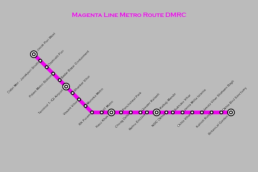
| # | Station | Connects Lines | Distance (km) | Time (min) | Fare (₹) |
| 1 | Krishna Park Extension | Magenta | 0.0 | 0 | 10 |
| 2 | Janakpuri West | Magenta → Blue | 5.0 | 8 | 20 |
| 3 | Dabri Mor – Janakpuri South | Magenta | 6.4 | 10 | 20 |
| 4 | Dashrath Puri | Magenta | 8.0 | 12 | 20 |
| 5 | Palam | Magenta | 9.6 | 14 | 20 |
| 6 | Sadar Bazar Cantt. | Magenta | 11.0 | 16 | 30 |
| 7 | Terminal 1‑IGI Airport | Magenta | 12.5 | 18 | 30 |
| 8 | Shankar Vihar | Magenta | 13.6 | 20 | 30 |
| 9 | Vasant Vihar | Magenta | 14.6 | 22 | 30 |
| 10 | Munirka | Magenta | 15.5 | 24 | 30 |
| 11 | R.K. Puram | Magenta | 16.4 | 26 | 30 |
| 12 | IIT Delhi | Magenta | 17.3 | 28 | 30 |
| 13 | Hauz Khas | Magenta → Yellow | 18.8 | 31 | 30 |
| 14 | Panchsheel Park | Magenta | 19.7 | 33 | 30 |
| 15 | Chirag Delhi | Magenta | 20.6 | 35 | 30 |
| 16 | Greater Kailash | Magenta | 21.5 | 37 | 30 |
| 17 | Nehru Enclave | Magenta | 22.3 | 39 | 30 |
| 18 | Kalkaji Mandir | Magenta → Violet | 23.0 | 41 | 40 |
| 19 | Okhla NSIC | Magenta | 24.5 | 44 | 40 |
| 20 | Sukhdev Vihar | Magenta | 25.3 | 45 | 40 |
| 21 | Jamia Millia Islamia | Magenta | 26.1 | 47 | 40 |
| 22 | Okhla Vihar | Magenta | 26.9 | 49 | 40 |
| 23 | Jasola Vihar Shaheen Bagh | Magenta | 27.8 | 51 | 40 |
| 24 | Kalindi Kunj | Magenta | 28.6 | 53 | 40 |
| 25 | Okhla Bird Sanctuary | Magenta | 29.4 | 55 | 40 |
| 26 | Botanical Garden | Magenta → Blue | 30.3 | 57 | 40 |
Delhi Metro Pink Line Route
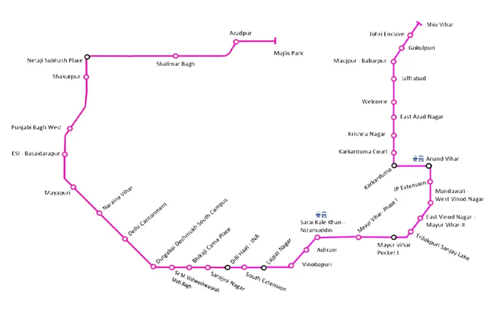
| # | Station | Line | Distance (km) | Time (min) | Fare (₹) |
| 1 | Majlis Park metro station | Pink | 0 | 0 | 10 |
| 2 | Azadpur metro station | Pink/Yellow | 2.3 | 4 | 20 |
| 3 | Shalimar Bagh metro station | Pink | 4.8 | 9 | 20 |
| 4 | NSP metro station | Pink/Red | 7.2 | 13 | 20 |
| 5 | Shakurpur metro station | Pink | 9.1 | 16 | 30 |
| 6 | Punjabi Bagh West metro station | Pink/Green | 11.3 | 19 | 30 |
| 7 | ESI Basaidarapur metro station | Pink | 13.1 | 22 | 30 |
| 8 | Rajouri Garden metro station | Pink/Blue | 15.9 | 26 | 30 |
| 9 | Mayapuri | Pink | 17.8 | 29 | 30 |
| 10 | Naraina Vihar metro station | Pink | 19.2 | 32 | 30 |
| 11 | Delhi Cantt metro station | Pink | 21 | 35 | 40 |
| 12 | Durgabai Deshmukh South Campus metro station | Pink/Orange | 23.5 | 39 | 40 |
| 13 | Sir M. Vishweshwaraiah Moti Bagh | Pink | 25 | 42 | 40 |
| 14 | Bhikaji Cama Place | Pink | 26.5 | 45 | 40 |
| 15 | Sarojini Nagar metro station | Pink | 28 | 48 | 40 |
| 16 | INA metro station | Pink/Yellow | 29.5 | 51 | 40 |
| 17 | South Extension metro station | Pink | 31.1 | 54 | 40 |
| 18 | Lajpat Nagar metro station | Pink/pink | 32.7 | 57 | 50 |
| 19 | Vinobapuri | Pink | 34 | 60 | 50 |
| 20 | Ashram | Pink | 35.2 | 63 | 50 |
| 21 | Sarai Kale Khan–Nizamuddin | Pink | 37 | 66 | 50 |
| 22 | Mayur Vihar Phase I metro station | Pink/Blue | 38.5 | 70 | 50 |
| 23 | Mayur Vihar Pocket I metro station | Pink | 40.1 | 72 | 50 |
| 24 | Trilokpuri Sanjay Lake | Pink | 41.8 | 75 | 60 |
| 25 | East Vinod Nagar–Mayur Vihar II | Pink | 43.4 | 78 | 60 |
| 26 | Mandawali metro station | Pink | 45 | 81 | 60 |
| 27 | IP Extension metro station | Pink | 46.6 | 84 | 60 |
| 28 | Anand Vihar metro station | Pink/Blue | 48.3 | 87 | 60 |
| 29 | Karkarduma metro station | Pink/Blue | 50 | 89 | 60 |
| 30 | Karkarduma Court | Pink | 51.2 | 92 | 60 |
| 31 | Krishna Nagar metro station | Pink | 52.7 | 95 | 60 |
| 32 | East Azad Nagar | Pink | 54.1 | 98 | 60 |
| 33 | Welcome metro station | Pink/Red | 55.7 | 101 | 60 |
| 34 | Jafrabad metro station | Pink | 57.2 | 104 | 60 |
| 35 | Maujpur–Babarpur (branch) | Pink | 58.5 | 106 | 60 |
| 36 | Gokulpuri metro station | Pink | 59.8 | 109 | 60 |
| 37 | Johri Enclave | Pink | 61.2 | 112 | 60 |
| 38 | Shiv Vihar metro station | Pink | 62.5 | 115 | 60 |
Delhi Metro Grey Line Route
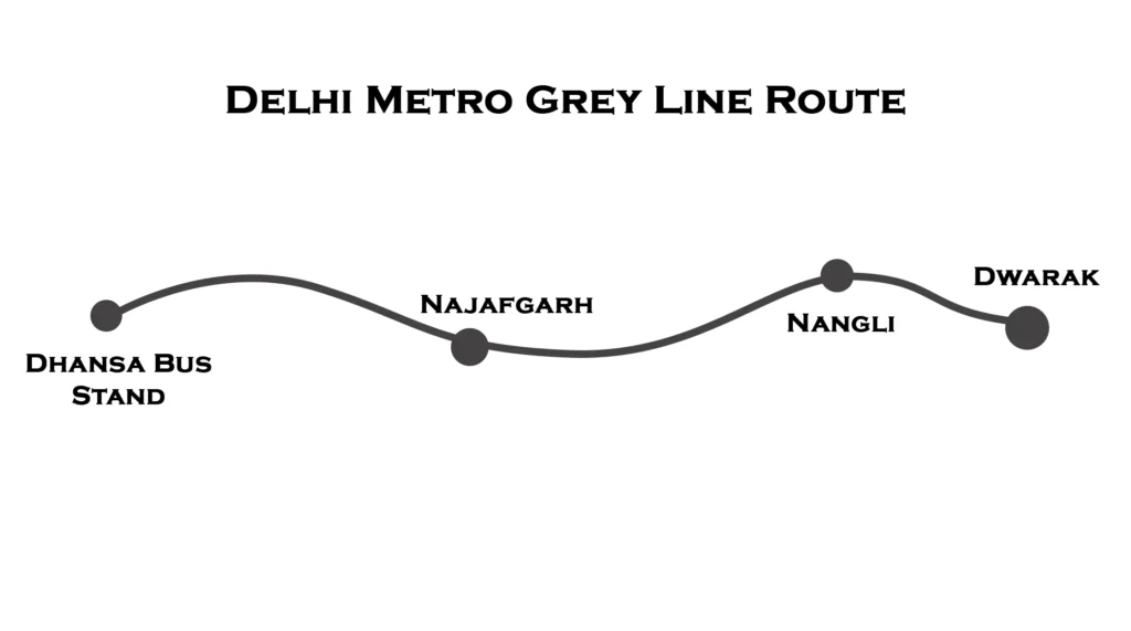
| Station No. | Station Name | Line | Distance from Dwarka (approx.) | Travel Time from Dwarka | Typical Fare* |
| 1 | Dwarka Metro Station | Grey | 0 km | 0 min | ₹10 (0-2 km) |
| 2 | Nangli Metro Station | Grey | ~2.0–2.5 km | ~3 min | ₹10–20 |
| 3 | Najafgarh Metro Station | Grey | ~4.0–4.5 km | ~6 min | ₹20 |
| 4 | Dhansa Bus Stand Metro Station | Grey | ~5.19 km | ~8 min | ₹30 |
Delhi Metro Orange Line or Airport Express Line
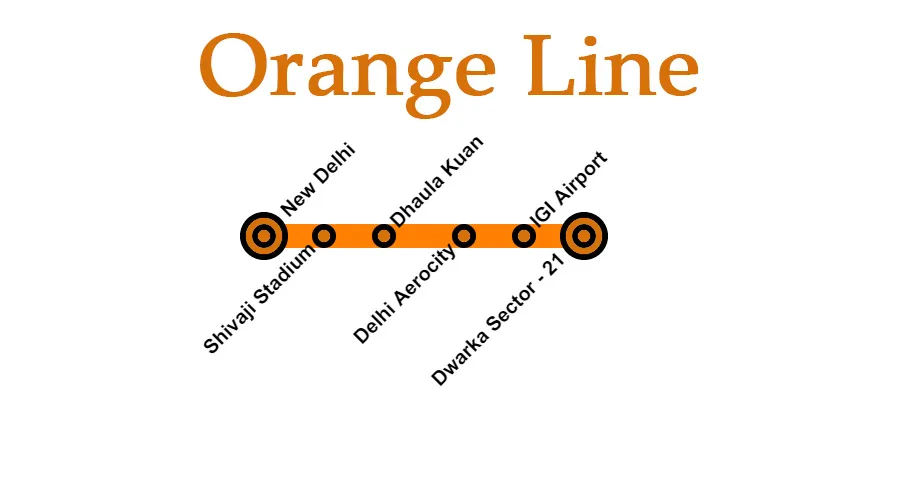
| Station Name | Distance from New Delhi (km) | Approx. Fare (INR) |
| New Delhi | 0.0 | – |
| Shivaji Stadium | 2.0 | 20 |
| Dhaula Kuan | 5.3 | 30 |
| Delhi Aerocity | 10.9 | 40 |
| IGI Airport (T3) | 14.8 | 50 |
| Dwarka Sector 21 | 22.7 | 60 |
| Yashobhoomi Dwarka Sec 25 | 24.9 | 70 |
How to Use the Delhi Metro Map for Travel Planning
Using the Delhi Metro Map for travel planning is simple and efficient. First, locate your starting station and destination on the map. Identify the metro line color and check if direct connectivity is available. If an interchange is required, find the nearest interchange station and follow the shortest route. Use online metro maps or mobile apps to calculate fares and travel time. Check first and last metro timings to avoid inconvenience. Look for station symbols indicating accessibility, restrooms, and other facilities. With proper planning, the Delhi Metro Map helps commuters navigate the city seamlessly while saving time and money.
- Step 1: Find your current station on the map
- Step 2: Locate your destination station
- Step 3: Identify the shortest route and interchange points
- Step 4: Check the first and last metro timings
Digital Delhi Metro Map & Mobile Apps
The digital Delhi Metro Map and mobile apps have revolutionized metro travel by providing real-time navigation and trip planning. Available on the DMRC website and apps, the map allows commuters to check routes, interchange stations, and estimated travel times. Integrated with Google Maps, it offers step-by-step directions, fare calculations, and first and last train timings. Mobile apps also provide live metro status, parking details, and accessibility features. With user-friendly interfaces, these digital tools help passengers avoid confusion and make informed travel decisions. Whether for daily commuters or tourists, the digital Delhi Metro Map ensures a seamless and efficient metro experience.
- Available on the DMRC website and apps
- Google Maps integration for route planning
- Features fare calculator, metro timings, and station facilities
Metro Expansion & Future Developments
The Delhi Metro network continues to expand with new routes and improved connectivity under Phase 4. This expansion aims to add over 100 kilometers of metro lines, enhancing links to outer Delhi, Gurgaon, Noida, and Ghaziabad. Several new corridors and extensions are under construction to reduce travel time and congestion. Advanced metro systems, including driverless trains and better station facilities, are being introduced. Future developments will also integrate metro services with other transport modes for seamless connectivity. With continuous upgrades, the Delhi Metro is set to become an even more efficient, eco-friendly, and accessible mode of transportation for millions.
Upcoming metro extensions:
- Phase 4 Expansion will add over 100 km of new metro routes
- More connectivity to Gurgaon, Noida, and Ghaziabad
Why the Delhi Metro Map is Important for Tourists
The Delhi Metro Map is essential for tourists as it simplifies navigation across the city’s extensive metro network. With clear color-coded lines and interchange stations, it helps visitors easily locate top attractions like Red Fort, India Gate, Qutub Minar, and Lotus Temple. It ensures an affordable, safe, and time-efficient mode of transport compared to taxis or buses. The map also highlights key connections to railway stations, the airport, and popular markets. Digital accessibility through apps makes trip planning even easier. For first-time travelers, the Delhi Metro Map is the best tool for exploring the city without confusion or delays.
- Easiest way to explore Delhi’s top attractions like India Gate, Lotus Temple, and Red Fort
- Affordable travel compared to taxis and buses
- Easy connectivity to railway stations and the airport
Common Mistakes While Using the Delhi Metro Map
Many commuters make common mistakes while using the Delhi Metro Map, leading to unnecessary delays and confusion. One frequent error is misinterpreting interchange stations, which can result in taking a longer route. Passengers also confuse similar station names, such as Noida Sector 15 and Noida Sector 16. Another mistake is not checking first and last metro timings, leading to missed trains. Ignoring fare details and entry-exit gates can cause inconvenience. Additionally, some travelers forget that certain metro lines have multiple terminal points, leading them in the wrong direction. Understanding the map properly can help avoid these issues and ensure smooth travel.
- Ignoring interchange stations and taking a longer route
- Confusing similar station names (e.g., Noida Sector 15 vs. Noida Sector 16)
- Not checking first and last metro timings
Conclusion
The Delhi Metro Map plays a vital role in simplifying travel across the city and its neighboring regions. With a well-structured, color-coded layout, it helps commuters navigate through multiple metro lines, interchange stations, and key locations effortlessly. Whether you are a daily passenger, a student, a professional, or a tourist, understanding the map ensures a smoother and more efficient journey.
As the Delhi Metro continues to expand, the map evolves to accommodate new routes and stations, enhancing connectivity and reducing travel time. Digital accessibility through websites and mobile apps has further improved the travel experience, allowing users to plan their routes, check fares, and find the fastest connections. With easy-to-read symbols and clear route markings, the map remains an essential guide for all metro users.
The importance of the Delhi Metro Map goes beyond convenience. It supports a sustainable and eco-friendly mode of transportation, reducing road congestion and pollution. As the city grows, the metro network will continue to be a lifeline for millions. By familiarizing yourself with the Delhi Metro Map, you can travel more confidently, make informed decisions, and enjoy a seamless commuting experience in one of India’s most advanced public transport systems.
By familiarizing yourself with the Delhi Metro Map, you can travel smarter, save time, and explore Delhi effortlessly. 🚇