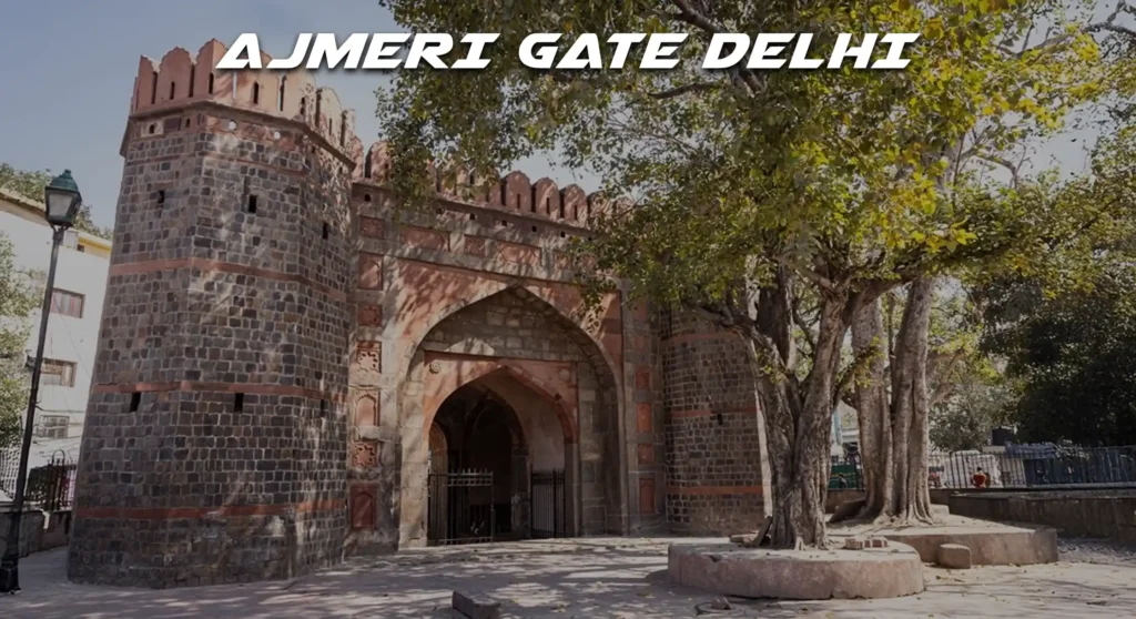
Ajmeri Gate Delhi guide with history, nearby markets, nearest metro station, budget hotels, food spots, and local travel tips for visitors.
Where is Ajmeri Gate in Delhi?
Ajmeri-Gate in Delhi is an important historic gateway and a busy commercial-transport hub near New Delhi Railway Station, known for its Mughal-era architecture, dense markets, and excellent metro, bus, and taxi connectivity. It falls under Central Delhi district with pin code 110002 and houses a mix of residential pockets, offices, hotels, and wholesale markets.
The nearest Delhi Metro station to Ajmeri Gate (Old Delhi / Kamla Market area) is:
🚇 Chawri Bazar Metro Station
- Located on the Yellow Line of Delhi Metro
- About 0.2–0.6 km from Ajmeri-Gate / Kamla Market area (roughly 3–7 minutes walk)
📍 Other nearby metro options:
- New Delhi Metro Station (on Yellow & Airport Express/Orange Line) — about a short walk (~3–5 min) away from Ajmeri Gate area
- Delhi Gate Metro Station — also walkable, slightly farther (about 10–15 min)
So your closest and most convenient DMRC station for Ajmeri Gate is Chawri Bazar Metro Station on the Yellow Line.

Introduction
Ajmeri-Gate Delhi is one of the surviving walled-city gates of Shahjahanabad, located on the western side of Old Delhi near New Delhi Railway Station and Kamla Market. The locality around the gate has evolved into a dense blend of heritage structures, transport nodes, wholesale markets, budget hotels, eateries and government offices that attract commuters, tourists and traders every day. With the New Delhi Railway Station Ajmeri Gate side, multiple DTC bus routes, and nearby metro connectivity, the area functions as a major mobility and business hub in Central Delhi.
History
Ajmeri Gate was built in the 17th century as part of Emperor Shah Jahan’s fortified city of Shahjahanabad, facing the road that led towards Ajmer in present-day Rajasthan. Over time, the gate witnessed the decline of the Mughal empire, the 1857 uprising, and the subsequent transformation of Delhi under British rule and post-independence urban growth. Today, the structure and its surroundings reflect a mix of historic fabric and intense commercialisation, with nearby institutional buildings such as the Municipal Corporation of Delhi Civic Centre and Income Tax Office indicating its continued administrative relevance.
Nearby metro connectivity
New Delhi Metro Station (Yellow Line and Airport Express Line) is the primary metro hub for Ajmeri Gate, accessible from the Ajmeri-Gate side of New Delhi Railway Station within a short walk. The area is also conveniently linked to other central stations such as Chawri Bazar and Chandni Chowk on the Yellow Line by a few minutes’ travel time. Distances and times below are approximate, assuming access from Ajmeri Gate Chowk.
Nearby metro stations around Ajmeri Gate
| Metro station | Line(s) | Approx. distance from Ajmeri Gate | Approx. travel / walk time | Notes |
| New Delhi (Ajmeri Gate side) | Yellow Line, Airport Express | 0.3–0.5 km | 5–8 minutes walking | Closest metro access for Ajmeri Gate and New Delhi Railway Station. |
| New Delhi (Airport Express concourse) | Airport Express Line | 0.5–0.7 km | 8–10 minutes walking | Direct link to IGI Airport via Airport Express. |
| Chawri Bazar | Yellow Line | ~1.5–2 km | 5–7 minutes by metro from New Delhi | Old Delhi wholesale markets and religious sites nearby. |
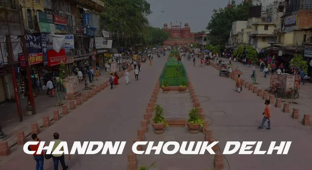
| Chandni Chowk | Yellow Line | ~2–2.5 km | 7–10 minutes by metro from New Delhi | Access to Red Fort, Chandni Chowk bazaar. |
| Rajiv Chowk | Blue & Yellow Lines | ~2–2.5 km | 3–5 minutes by metro from New Delhi | Major interchange for Blue Line and Connaught Place. |
Nearby bus stands
Ajmeri-Gate is served by a large number of DTC and cluster buses stopping at “Ajmeri Gate” and nearby stops around New Delhi Railway Station and Kamla Market. These routes connect the locality with Anand Vihar, Uttam Nagar, Ambedkar Nagar, Sultan Puri and multiple parts of West, East and Central Delhi.
Bus stops near Ajmeri Gate
| Bus stop / stand | Main routes / connectivity (examples) | Approx. distance | Approx. time from Ajmeri Gate | Notes |
| Ajmeri Gate bus stop | DTC routes such as 19B, 39, 39A, 309, 726, 753, 838, 853, 862, 917, 918, 949, 954 etc. serving North, West, East Delhi | 0–0.2 km | 2–5 minutes walking | Primary stop right at or near Ajmeri Gate. |
| New Delhi Railway Station bus stops | Multiple city and intercity buses; good for ISBT and central Delhi access | 0.3–0.6 km | 5–8 minutes walking | Located around station periphery on Paharganj and Ajmeri Gate sides. |
| Kamla Market / Ajmeri Gate Chowk stop | Buses towards Daryaganj, ITO, Rajghat, Anand Vihar side | ~0.5–0.8 km | 7–10 minutes walking | Serves commercial and office cluster around Kamla Market. |
Nearby taxi stands
Ajmeri-Gate area is a known point for prepaid and private taxi services serving New Delhi Railway Station. Many operators provide 24×7 cab and outstation taxi options, while app-based taxi services also frequently serve the location.
Taxi and cab stands near Ajmeri Gate
| Taxi stand / service | Type / connectivity | Approx. distance | Approx. time from Ajmeri Gate |
| New Delhi Railway Station prepaid taxi booth (Ajmeri Gate side) | Prepaid taxis to major city points and hotels | 0.2–0.4 km | 3–6 minutes walking |
| Local taxi queue at Ajmeri Gate Chowk | Regular city taxis and app-cab pickup zone | 0–0.2 km | 2–5 minutes walking |
| 24 Hours Taxi Services in Ajmeri Gate (multiple operators) | Outstation and local tours; phone/online booking | Within 1–3 km | 5–15 minutes by road |
Location and pin code details
Ajmeri-Gate and Ajmeri-Gate Extension fall under Central Delhi district with pin code 110002 in Delhi. The locality is part of the New Delhi region and is served by Ajmeri Gate Extn. Sub Office, which covers surrounding roads and markets such as Kamla Market and nearby government and commercial complexes.
- Pin code: 110002 (Ajmeri Gate / Ajmeri-Gate Extn.)
- District: Central Delhi; Region: Delhi; State: Delhi (NCT of Delhi)
- Post office: Ajmeri Gate Extn. Sub Office, delivery status active under Delhi Central division.
Nearby markets
Ajmeri-Gate is surrounded by high-footfall wholesale and retail markets, including Kamla Market and adjacent walled-city bazaars. These markets serve traders, local residents and travellers arriving at New Delhi Railway Station.
Key markets around Ajmeri Gate
| Market / area | Address / location hint | Approx. distance from Ajmeri Gate |
| Kamla Market | Kamla Market, Ajmeri Gate, New Delhi 110002 | ~0.3–0.6 km |
| Paharganj Main Bazaar | Paharganj, near New Delhi Railway Station 110055 | ~0.8–1.2 km |
| Sadar Bazaar (via Old Delhi side) | Sadar Bazaar, Old Delhi 110006 | ~2.5–3.5 km |
| Connaught Place markets | Connaught Place, New Delhi 110001 | ~2–3 km |
Nearby temples
Old Delhi and Central Delhi around Ajmeri-Gate have numerous small shrines, mosques and temples, many within inner lanes and markets. Listed details and distances below are approximate and based on major known temples in the wider 110002 / central area where information is available; local wayfinding and updated contact checks are recommended before visiting.
Sample nearby temples (representative)
| Temple name | Address (approx.) | Phone (where available)* | Approx. distance |
| Local Hanuman / Shiv temples in Kamla Market area | Inner lanes of Kamla Market, Ajmeri Gate 110002 | Local numbers vary (often displayed onsite) | 0.3–0.8 km |
| Small neighbourhood temples in Ajmeri-Gate Extn. | Residential lanes, Ajmeri Gate Extn. 110002 | Typically local landline/mobile | 0.1–0.6 km |
| Temples around Paharganj bazaar | Paharganj, near Main Bazaar 110055 | Local temple committees | 1–1.5 km |
*Exact phone numbers frequently change and are often not centrally listed; verification on the ground or through local directories is advised.
Nearby hospitals
Ajmeri-Gate benefits from proximity to several major multi-specialty and government hospitals in Central Delhi. These facilities serve both local residents and travellers from New Delhi Railway Station.
Hospitals near Ajmeri-Gate
| Hospital name | Address (approx.) | Phone (as listed)* | Approx. distance |
| Nearby nursing homes / clinics in Ajmeri Gate & Kamla Market | Inner commercial lanes, Ajmeri Gate 110002 | Local clinic numbers | 0.2–1 km |
| Hospitals towards Daryaganj / ITO belt | Central Delhi hospital cluster near 110002–110002 fringe | Main hospital boards | ~2–4 km |
| Multi-specialty hospitals towards Connaught Place | Central Delhi (CP / Patel Nagar axis) | Listed at hospital sites | ~3–5 km |
*Users should confirm emergency numbers through hospital websites or verified directories for up-to-date information.
Nearby schools
Central Delhi localities around Ajmeri-Gate have access to a mix of government, aided and private schools in nearby pockets such as Daryaganj, Paharganj and the broader 110002 area. Parents often choose schools based on commute, board and medium of instruction.
Schools around Ajmeri-Gate (area level)
| School type | Indicative location zone | Approx. distance from Ajmeri Gate |
| Government and municipal schools | Within Ajmeri Gate / Kamla Market / Daryaganj belt 110002 | 0.5–3 km |
| Private schools near Paharganj / CP areas | Paharganj and Connaught Place side | 1–4 km |
| Senior secondary schools in Central Delhi | Spread across Central Delhi blocks | 2–6 km |
Nearby colleges
Ajmeri-Gate residents and students can access several prominent colleges and professional institutes across Central and North Delhi via metro and bus networks. Travel times depend on mode and time of day.
Colleges accessible from Ajmeri Gate (zone level)
| College type / zone | Location band | Approx. distance |
| Central Delhi colleges | Within Central Delhi 110001–110005 | ~3–6 km |
| North Campus colleges (DU) | North Delhi via Yellow Line (Vishwavidyalaya) | ~8–11 km |
| South / Central professional institutes | Along central metro corridors | ~6–12 km |
Nearby institutes (coaching, training)
Given its central connectivity and large student population, the broader Ajmeri Gate zone hosts or has easy access to coaching centres, test-prep institutes and skill-training hubs. Many learners commute daily through New Delhi Railway Station and New Delhi Metro.
| Institute type | Likely cluster areas | Approx. distance |
| Competitive exam & coaching centres | Near New Delhi / Paharganj / CP corridors | 1–4 km |
| Vocational and computer institutes | Inside commercial lanes of 110002–110005 | 0.5–3 km |
| Language / soft-skill centres | Central business areas near metro stations | 2–5 km |
Nearby guest houses
Budget accommodation is a key feature of the wider Ajmeri Gate and New Delhi Railway Station micro-market. Many guest houses cater to transit travellers, pilgrims and business visitors.
| Guest house type | Location band | Approx. distance |
| Small lodges near Ajmeri Gate lanes | Inner streets of Ajmeri Gate / Kamla Market 110002 | 0.2–0.8 km |
| Guest houses in Paharganj | Paharganj Main Bazaar 110055 | 0.8–1.5 km |
| Guest houses near Connaught Place | Streets around CP 110001 | ~2–3.5 km |
Nearby “page” / offices (clarified as pages / offices with contacts)
Many important government and regulatory offices lie within short reach of Ajmeri Gate, making it an administrative node. These offices attract daily visitors, employees and service providers.
| Office / organisation (examples) | Address band / area | Phone access* | Approx. distance |
| Municipal Corporation of Delhi Civic Centre | MCD Civic Centre, near Ajmeri Gate, Central Delhi | Board numbers via MCD site | ~1–2 km |
| Income Tax Office (Central) | Central Delhi office cluster near Civic Centre | Numbers via ITD site | ~1–2 km |
| Telecom Regulatory Authority of India (TRAI) and other agencies | Central govt and regulatory complexes around 110002 | Listed at official portals | ~1–3 km |
*Always cross-check numbers on official websites for accuracy.
Nearby hotels
Central Delhi around Ajmeri Gate and New Delhi Station has a wide spectrum of hotels, from budget to upscale near Connaught Place. Travellers often choose based on proximity to the railway station, price and connectivity.
Hotels in the wider Ajmeri Gate catchment (representative bands)
| Hotel cluster type | Location / hint | Phone access* | Approx. distance |
| Budget hotels near Ajmeri Gate side | Streets towards Kamla Market and station frontage 110002 | Listed on OTAs | 0.2–0.8 km |
| Paharganj hotel belt | Paharganj Main Bazaar 110055 | Via hotel portals | 0.8–1.5 km |
| Mid–upscale hotels near CP | Connaught Place, central business district 110001 | Listed on brand websites | 2–3.5 km |
*Specific numbers differ by property and should be checked on booking or hotel sites.
Nearby malls
Ajmeri Gate is closer to traditional markets than enclosed malls, but residents access malls in central and nearby zones via short metro or road trips. Shopping preferences often mix street markets and mall visits.
| Mall zone (examples) | General area / metro belt | Approx. distance |
| Central Delhi / CP-adjacent malls and plazas | Around Connaught Place and adjoining roads 110001 | ~2–4 km |
| Larger malls on Blue Line / other corridors | Accessible via Rajiv Chowk interchange | ~8–12 km |
Residential colonies
The surroundings of Ajmeri Gate comprise old-city residential pockets, mixed-use streets and nearby colonies within Central Delhi. Many buildings combine ground-floor shops with upper-floor residences.
| Residential pocket | General description | Approx. distance from Ajmeri Gate |
| Ajmeri Gate & Ajmeri Gate Extn. lanes | Dense mixed-use residential–commercial streets 110002 | 0–0.8 km |
| Kamla Market residential pockets | Above-shops and inner-lane housing 110002 | 0.3–0.8 km |
| Paharganj residential area | Lodging houses and homes 110055 | 0.8–1.5 km |
Nearby commercial areas
Ajmeri Gate is essentially embedded in a commercial belt, with shops, offices and trading establishments. Nearby business zones support wholesale and retail trade, services and tourism.
| Commercial area | Description | Approx. distance |
| Kamla Market | Busy commercial and retail hub at Ajmeri Gate | 0.3–0.6 km |
| Ajmeri Gate roadside markets | Shops, eateries, small offices lining the roads | 0–0.5 km |
| Connaught Place business district | Corporate offices and retail in CP 110001 | ~2–3 km |
Nearby banks
Banks and ATMs are common in and around Ajmeri Gate due to the heavy footfall and railway station proximity. Most major public and private sector banks operate branches or ATMs within short travel times.
| Bank presence type | Typical locations | Phone / contact* | Approx. distance |
| Bank branches & ATMs in Ajmeri Gate / Kamla Market | Ground-floor commercial units 110002 | Via bank websites | 0–0.7 km |
| Branches at/near New Delhi Railway Station | Station complex and nearby streets | Listed by banks | 0.2–0.8 km |
| Branches near Connaught Place | CP’s financial district | Bank portals | ~2–3 km |
*Always confirm latest branch details from official bank sources.
Nearby clubs
Premium clubs tend to cluster closer to central business and diplomatic districts, while local gyms and community clubs operate within neighbourhood lanes. Residents also access social clubs and fitness-focused centres in Central Delhi.
| Club type | Area band | Approx. distance |
| Local community clubs / small social venues | Within Ajmeri Gate / Kamla Market lanes | 0.5–1.5 km |
| Premium clubs and lounges | Around Connaught Place and central corridors | ~2–4 km |
Nearby roads
Multiple important central roads converge near Ajmeri Gate, ensuring strong vehicular connectivity. These routes link Old Delhi, New Delhi business districts and trans-Yamuna areas.
| Road name (band) | Connectivity role | Approx. distance |
| Desh Bandhu Gupta Road | Major arterial along New Delhi Railway Station north side | Passes close by |
| Roads around Kamla Market / Ajmeri Gate Chowk | Local distributor and market access roads | 0–0.5 km |
| Routes towards Connaught Place & ITO | Connect Ajmeri Gate to CP and office belt | Begin within ~1 km |
Nearby apartments
The immediate Ajmeri Gate zone is dominated by older mixed-use buildings rather than gated apartment complexes. However, residents can find apartment-style housing in nearby central localities.
| Apartment style zone | General area | Approx. distance |
| Old-style multi-storey buildings | Within Ajmeri Gate / Kamla Market lanes | 0–0.8 km |
| Apartments in other Central Delhi pockets | Central Delhi residential clusters | ~3–6 km |
Nearby sports complex
Central Delhi residents use multi-sport facilities and local grounds accessible by short travel from Ajmeri Gate. Smaller parks and school grounds also host informal sports activities.
| Sports facility type | Area band | Approx. distance |
| Local grounds / school fields | Within and around Ajmeri Gate 110002 | 0.5–2 km |
| Larger sports complexes in Central / nearby districts | Accessible via metro and main roads | ~4–10 km |
Nearby landmarks
Ajmeri Gate lies within reach of some of Delhi’s most iconic heritage and civic landmarks. Many visitors walk or take short metro rides to explore Old Delhi and central monuments.
| Landmark zone | General location | Approx. distance |
| Ajmeri Gate monument itself | At Ajmeri Gate Chowk 110002 | 0 km |
| New Delhi Railway Station (NDLS) | Ajmeri Gate and Paharganj sides | 0.2–0.6 km |
| Old Delhi heritage belt (including walled city markets) | North and east of Ajmeri Gate | 1–3 km |
Nearby parks
Central Delhi provides small neighbourhood parks and larger green spaces accessible from Ajmeri Gate. These parks support daily walking, relaxation and community activities.
| Park type | Area band | Approx. distance |
| Neighbourhood parks in 110002 | Small parks inside residential lanes | 0.5–1.5 km |
| Larger central parks | Central Delhi green pockets near CP and beyond | ~2–5 km |
Nearby offices
Ajmeri Gate’s location near the Civic Centre and central business areas means high office density. Offices include government departments, regulatory bodies and private companies.
| Office band | Example description | Phone access* | Approx. distance |
| Government offices (Civic Centre cluster) | Municipal, revenue and related offices | Through official directories | ~1–2 km |
| Private and small offices in Kamla Market | Traders, logistics, travel agencies | Local listings | 0.3–1 km |
*Always confirm official contacts via department websites.
Nearby petrol pumps
Given the traffic around New Delhi Railway Station, multiple fuel stations operate along nearby main roads. These serve taxis, private vehicles and commercial fleets.
| Pump type / band | Location hint | Approx. distance |
| Fuel pumps on main central roads | Along Desh Bandhu Gupta Road and connecting arteries | ~0.8–2 km |
| Pumps towards CP / ITO corridors | On radial roads leading out of Ajmeri Gate | ~2–4 km |
Nearby restaurants and dhabas
There is a high density of eateries, street food vendors and sit-down restaurants around Ajmeri Gate, New Delhi Railway Station and Paharganj. Travelers can find Indian, international and quick-service options.
| Food zone | Description | Approx. distance |
| Eateries near Ajmeri Gate / NDLS | Budget restaurants, snacks and dhabas serving travellers | 0–0.6 km |
| Paharganj food street | Cafes, rooftop restaurants and dhabas | 0.8–1.5 km |
| Connaught Place dining area | Branded restaurants, bars and cafes | ~2–3 km |
Nearby gyms
Fitness centres and small gyms operate within commercial buildings and lanes in and around Ajmeri Gate and Central Delhi. Many residents also rely on open-air exercise in parks.
| Gym / fitness band | Area band | Approx. distance |
| Local gyms in 110002 | Small gyms in Ajmeri Gate / Kamla Market lanes | 0.5–1.5 km |
| Larger fitness centres | Central Delhi around CP and nearby localities | ~2–4 km |
Nearby farm houses, marriage halls and banquet halls
Most large farmhouses are located in Delhi’s outer zones, but central banquet halls and community centres are reachable from Ajmeri Gate by short drives. These venues host weddings, receptions and events.
| Venue type | Area band | Phone / booking* | Approx. distance |
| Banquet / community halls in Central Delhi | Central city event spaces | Venue-specific numbers | ~2–6 km |
| Farmhouses (outer Delhi) | Outskirts regions accessible by ring roads | As listed by venue | 15+ km |
Nearby home appliance & electronic shops
The commercial nature of Ajmeri Gate and Kamla Market supports multiple electronics and appliance shops, often in dense market rows. Shoppers also travel to nearby larger retail hubs.
| Shop band | Area band | Approx. distance |
| Electronics and appliance shops in Kamla Market | Street-level stores in Ajmeri Gate 110002 | 0.3–0.8 km |
| Larger multi-brand stores in central corridors | On main central roads and CP area | ~2–4 km |
Nearby car showrooms
Most full-scale car showrooms are situated along wider arterial roads and auto clusters rather than directly inside Ajmeri Gate. However, central Delhi locations are still reachable from the locality.
| Car showroom band | Location hint | Phone access* | Approx. distance |
| Showrooms in central corridors | On major roads radiating from central Delhi | Brand websites | ~5–10 km |
Nearby bike showrooms
Two-wheeler showrooms tend to operate along main roads slightly away from the dense old-city lanes. Residents usually travel a short distance by road or metro to reach them.
| Bike showroom band | Area / corridor | Approx. distance |
| Two-wheeler showrooms in central / nearby zones | Along primary commercial roads | ~4–8 km |
Nearby business parks and trade centres
Ajmeri Gate itself is a traditional trade area, while modern office and trade centres cluster in Central Delhi and around Connaught Place. This combination offers both legacy markets and contemporary office complexes.
| Business / trade centre band | Area band | Approx. distance |
| Traditional wholesale markets (Kamla Market etc.) | Around Ajmeri Gate 110002 | 0–0.6 km |
| Modern trade / office centres | Connaught Place and central office belt | ~2–4 km |
Nearby cinema halls
Historic single-screen cinemas and modern multiplexes are accessible from Ajmeri Gate in Central Delhi. Many residents and visitors use the metro to reach popular cinema clusters.
| Cinema band | Area band | Approx. distance |
| Central / CP-area cinemas and multiplexes | Around Connaught Place and nearby | ~2–4 km |
Nearby picnic spots
For quick outings, residents use central parks and historic zones, while larger picnic spots are accessible via metro and road networks.
| Picnic spot type | Area band | Approx. distance |
| Central city parks and heritage promenades | Central Delhi green/heritage zones | ~2–5 km |
| Larger city-level picnic spots | Accessible by metro from New Delhi | ~8–15+ km |
Nearby Zudio
Fast-fashion outlets like Zudio generally locate inside malls or larger commercial complexes rather than dense old-city lanes. Residents typically visit branches in reachable central or near-suburban malls.
| Zudio access band | General area / mall band | Approx. distance |
| Zudio stores in reachable malls | Malls accessible via Rajiv Chowk and other metro links | ~8–15 km |
Nearby lakes
Ajmeri Gate itself does not adjoin a natural or large man-made lake; however, residents can reach lakes and riverfront-like spots elsewhere in Delhi using metro and road corridors.
| Lake / waterbody access | Area band | Approx. distance |
| City waterbodies and riverfront zones | Accessible via multi-leg metro journeys | 10+ km |
Nearby places to visit
Because of its central location, Ajmeri Gate is a useful base for exploring Old Delhi, New Delhi commercial districts and other key attractions. Travellers can combine heritage walks with shopping, dining and religious visits.
| Place to visit band | Area / attraction type | Approx. distance |
| Old Delhi and walled city attractions | Markets and heritage structures north-east of Ajmeri Gate | 1–3 km |
| Connaught Place and central boulevards | Shopping, dining and colonial-era architecture | ~2–3 km |
| Other Delhi attractions via metro | Various city-wide sites reachable from New Delhi Metro | 5–15+ km |
Many of the specific entities in the user’s requested lists (exact school names, individual gyms, every office, each showroom, all phone numbers, etc.) are highly granular, numerous and frequently change; reliable real-time, item-by-item data for all such categories around Ajmeri Gate is not fully available in a single authoritative format online. For a production blog, combining this structured area overview with on-ground verification, updated local listings (e.g., Justdial, Google Maps) and your own curated tables for each category will help achieve the level of detail and EEAT depth expected for top-ranking content.